|
Closing thoughts on Route 66 Total miles ridden, St. Charles to St. Charles (see Katy Trail post also), just over 700 and 23 days including some zero days. Total miles traveled, about 800. If you use Google maps for cycle directions in unfamiliar areas, use caution. Riding the gravel/rocky roads from Olathe (O-lay-tha) was not what I expected and I would not wish it on anyone. Same with some of the other highway riding, including Highway O previously mentioned. The best moments, the ones that really touched me, were when the people I met showed kindness, in their own way or told me I inspired them. I hope you've enjoyed this travelogue; let me know by posting your comments or questions. Stay tuned for the next adventure, likely in the fall a little closer to home. Chesterfield to St Charles and end, 15.2 After crossing the Missouri River on the Daniel Boone Memorial Bridge, I was “home free”, riding again on the Katy Trail for the remaining miles back to my car and hotel. Pacific to Chesterfield, 24 miles I picked up the Allenton Road, which goes through Six Flags Resort, and is a popular cycling route. Comforting to know that this back road is familiar to both drivers and cyclists. First 5 or so miles was all climbing but I felt good and made it to the summit parking area where I chatted with a road cyclist while I caught my breath. The road wends through Greensfelder County Park, where mountain bikers, hikers, and equestrians share heavily shaded trails. Sullivan to Robertsville State Park/Pacific Well the route I picked to the State Park was really a bad one, via State Highway O. Hilly, no shoulder, fast cars and commercial big rigs. If you use Google maps for any of your touring routing, be cautious. They are very far from perfect. I was quite fortunate to ask for and get a ride from a kind person, Mitch, who drove me 6 miles to the town of Pacific. I was ready to quit riding after this scary day! Phillipsburg to Meremec State Park Jesse from Safe Rides Lebanon picked me up right on time and loaded my bike into his truck, and he dropped me off in Sullivan, MO, with about 6 miles to ride to the campground. I was warned of a “steep climb” to get to the campground. No kidding. I suspect it was a bout a mile of steep, uphill walking/pushing Stanley. All the while I’m thinking about getting back, 2 days later! The campground was beautiful and I vowed to do nothing for the next 2 days but read and relax. It was hot, but I took my chair over to the Fisher Cave and enjoyed the bug free, natural air conditioning. In spite of due diligence, the racoons got into my food pannier (who knew they could open zippers?) and ate all my lunch and snack foods including 2 packages of gel blocks and half a tube of Nuun. Wondering how that set in their little stomachs. I was able to get a lift out of the park and thankfully didn’t have to walk down the steep hills with my loaded bike. Springfield to Phillipsburg, 48.3 Today was a sufferfest of heat and climbs. Oh, and navigating out of towns is always a challenge for me. I got about ½ mile of downhill, then a mile of uphill. Stanley continues to perform well but sometimes I wish he had an auxiliary power source. After reviewing the elevation profiles for the next few days, I’m thinking of how I might get a lift up the route a bit. I arrived at Rustic RV Park and met the hosts, Dee and Bruce. I was able to find a lift to save me almost 100 miles of misery and though expensive, I did it. I don’t want to suffer ALL the time! Bruce and Dee invited me to dinner and I had a wonderful time hearing their stories. Bruce was a cowboy, as in herding and caring for cows in the middle of nowhere, mostly on BLM land, all over the Western US including Washington and Oregon. They are pushing 80 years old but I would not have guessed. They are vibrant, quick-witted, and still ride and care for their horses and a small farm. Miller to Springfield, 37.4 miles Rolling hills to steep climbs. I did some walking to rest. The highlight of this day was meeting a large group of motorcycle tourists at Paris Springs. I regret not getting more photos! Joplin to Miller, MO, 57.9 Leaving Joplin, I picked up the Frisco Greenway toward Webb City. I met Andy, who was out for his daily ride and has dreams of doing some touring. We had a great conversation and I hope I inspired him to keep dreaming and planning. As I climbed a hill outside of Carthage, a man waved me over to stop at this little campground store. He offered to buy me a cold drink…no way I could turn that down! He told me about his tree business and his grandkids reported on their recent trip to Florida. This encounter cancelled out the dog encounter below. Dogs – sometimes they are pretty terrifying when they race out to the road, barking and growling. I instantly stop and try to keep Stanley between me and them. But when there’s more than one, they tend to surround me. Today, one particularly aggressive dog attacked my pannier and was biting it. I dropped my bike and grabbed a water bottle. For all the good it’s gonna do me. It’s usually a hurry up and wait for the dogs to lose interest, which they eventually did. I found a quiet school yard to camp in, which had plenty of power outlets. Prairie State Park to Joplin, 37.3 miles More gravel but at least it’s flat and easier to ride on. The last 10 miles into Joplin and a hotel room was on Highway 171, busy and fast traffic, but a wide shoulder clear of debris. I had a nice break on the way, setting up my chair, drinking ice cold tea and a pre made sandwich made on “wonder bread”. Haven’t eaten that kind of bread since I was a kid. Oh, was it good! Once checked into the hotel, I walked to the nearby grocery store and got salad and some deli chicken. Great to have fresh food! Day 13, Fort Scott to Prairie State Park, 29 miles and more gravel
I took a break just 4 miles from the State Park, in Mulberry, Kansas, a former mining town, population about 500. Set up my chair (oh how I love my Helinox Zero!) and discovered the county provides free wi-fi! So, I just relaxed and checked the weather. Turns out the rain was coming, so I packed up and raced onward to the park (please no gravel). Well the last 1.5 mile was gravel but much easier riding than previous days. Made it to a nice campsite, sheltered by the trees and barely got wet. Day 12, Pleasanton to Fort Scott, 27 miles and only 7.5 gravel I have been a little surprised, with all the traffic on the gravel roads, that no one has stopped to ask me what I'm doing out there in farm country. Well today, Randy Ratty stopped and we had a nice chat for awhile. He's proud to say he's retired from the power plant where his high risk job paid well and set him up for a comfortable retirement. Arriving in Fort Scott, I again opted for a hotel, the Courtland, built in around 1900 and restored in the 80's. It's just a lovely, and homey place. I felt welcomed when I walked into my room, decorated with antique furniture, muted colors, and a quilt that my grandmother could have made. Fort Scott was a very important military base during the early days of of the US. Anybody traveling near there should take the opportunity to visit. The Race Across America goes through there and although the cyclists don't really stop, there's plenty of support crew who spend money and time in the town. Day 11, Linn Valley to Pleasanton, 17 miles Short day, 90% gravel. Stanley performed well and continued to amaze me with his agility on these miserable roads. I had a great burger at Cookees in Pleasanton. It's a 50's style diner and chatted with the owner about what goes on in Pleasanton with a population of about 1400. She told me that the following week, the annual Christian motorcycle ride will be descending on this small town, with about 1000 riders. There's a motorcycle museum and another regional museum; both closed today. Hunting is popular, as is living here and working in Kansas City. I made my way to the vast city park with a lake and several stone shelters. Spread out my ground cloth, and just relaxed rest of day. There's no water available, but a kind neighbor brought me into his home and let me fill everything from his refrigerator tap. Day 10, Olathe to Linn Valley 46 rough miles What's with all this gravel??? I had no idea I'd be riding on gravel/rock roads. It was slow going and much walking on these rough roads. Oh, and some hills too. Some of the rock was too difficult to ride on so I walked quite a bit. This day was about 85 percent gravel and little did I know that there was oh so much more to come. I made it to Linn Valley Park, a private camp/park/lake. I was very grateful to be able to camp there, close to bathrooms and showers. The nice security lady, Janet was kind enough to give me two cold bottles of water. Pitched my tent and was asleep before dark.
7 Comments
Onward to Leeton then Pleasant Hill On the way to Leeton to camp in the city park, we stopped in Windsor and found the only place open - the Side Track Cafe. We had the best ever burgers before traveling the remaining 10 miles. We're now on the Rock Island Spur, a route that continues northwest to Kansas City. Continuing on to Pleasant Hill to camp the following night, Jim will then proceed to Lee's Summit (southeast of Kansas City), where he'll catch Amtrak back to his car in St Louis and head home. I'll continue to Olathe for two nights in a hotel before heading south/southwest to Joplin. Day 5, Pilot Grove to Sedalia, 28 miles We got a few bonus miles today, looking for the fairgrounds in Sedalia, where we planned to camp. Turning unexpectedly colder. I chatted with Jeff from Rolla, on the trail, who's starting a new gravel touring business. He offered me his front yard for camping, when I get to Rolla on my return leg to St Charles. Sedalia was given the choice to have the state college or the fairgrounds. They chose the fairgrounds. Sedalia has been hosting the Missouri State Fair since 1901 on almost 400 acres of grounds of 47 buildings. Day 4, McBaine to Pilot Grove, 38 miles Weather has been getting cooler during the day, necessitating long sleeves and sometimes leg coverings. We had read about the dreaded Salt Creek Detour...a bridge on the trail that had washed away in 2016 with no repairs planned. I had anticipated this, and found a road route that was actually quite nice; a change from the sandy surface and cave-like trees we'd mostly been riding through. After a 5 or so mile detour, we returned to the trail and had the opportunity to inspect the damages to the bridge. At some point, I'll upload photos. Some riders will trudge through the yucky mud and maybe 6 inches of water, to avoid riding on the road. After a heavy rain, even that option wouldn't be possible though. We picked up some bonus miles in Booneville as I searched for someplace to buy cheap reading glasses as I had left mine at the hostel. No glasses, but we did discover an A&W Root Beer stand with the oh so yummy root beer freezes. Made a great lunch! Pilot Grove is a delightful little town with a wonderful city park that welcomes bike travelers to camp for free. Covered shelters, bathrooms, and water available. The local Dollar General was a 3 minute walk in one direction and I got my glasses. A few minutes the other direction was a Casey's market/gas station, in case there's something you need that Dollar General didn't have. We met a nice man, Tim, riding a recombant trike. He's from Indiana and was also riding the Katy, but both directions. His great sense of humor in sharing his stories, including that he's had six (yes, six) strokes and a heart attack made for a pleasant evening of conversation. He has some mobility and vision limitations, but dang, he's out there riding self supported. A great inspiration! Day 3, Tebbetts to McBaine, 46 miles We decided to make this day a few miles longer, so that the following day would be less than 40 miles as I had originally planned. I've enjoyed riding with Jim, my ride buddy, as we came up with ideas to maximize our energies and time. Anyway, there was no place to camp in McBaine. So, we found a place near the sewer plant to stealth camp (odor-free!). Day 2, Marthasville to Tebbetts, 54 miles Even though the trail appears flat, there's a grade of no more than 2 percent. On a road, it would not even be noticeable, but with a total bike weight close to 70 pounds and soft surface, it's VERY noticeable. A storm was due this day, and although the worst went north of us, we still got free showers before getting to Tebbetts. We stopped in the tiny town of Mokane, and ducked into the local bar to wait for the rain to stop. We had a beverage and a delightful conversation with Jennifer the young bartender, with lots of ideas to attract the cyclists along this popular route. Arriving at the hostel in Tebbetts was a welcome sight after this long soggy day. We had called ahead and were advised where the key was hanging and that we put our $6 in an envelope and drop it in the US mail box over at the post office. When full, the hostel accommodates about 40 travelers but there were just 3 others joining us this night. The kitchen was adequate and showers were hot. We spent some time washing off the sticky grit from our bikes before storing them in the adjacent storage area. Day 1, St. Charles to Marthasville, 39 miles Marthasville is a small town with a population of less than 2000. We're camping at the local ballfields (game night!) and I think everyone in town must be here. The food vendor is open for business and provided us with a cold beer while setting up our tents. We had both electricity and showers for a camp fee of $6. We're sharing this nice space (covered picnic tables and farm equipment) with four other travelers, going the opposite direction. Apparently Daniel Boone called this town home and he was originally buried here. At some point his remains were relocated to Kentucky. Missouri has never gotten over that. I was fortunate to connect with a fellow bike tourer via Warmshowers.org and we'll be riding together for about five days. Our first day is about 40 miles to the town of Marthasville to camp in a city park. The weather people warning of severe storms on Day 2, Thursday, but with an early start to ride the 50 miles to Tebbetts, we hope to reserve bunks at the Turner Katy Shelter and beat the worst of the storm. 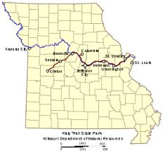 ; In looking forward to touring in 2021 I've decided, instead of taking the train to St. Louis for last years' deferred tour, I'll drive! I plan to visit some national parks, do some hiking and some trail running along the way. For a person who doesn't enjoy long drives, I'll load up on audio books and limit the number of driving hours per day, making for a longer crossing.
I bought an atlas and with several tour books on National Parks; I'm looking forward to visiting Death Valley, Grand Canyon, and others, car camping my way to St. Louis. When I arrive in St. Louis, a gracious WarmShowers host will allow me to park my car at their house for the 700 some miles of my bicycle tour. All the planning for the bicycle tour was already done and with a few tweaks, I'll be ready to hit the Katy Trail and beyond. Stay tuned... Corvallis to Willamette Mission State Park, 49 miles, 1047 elevation Somewhat cooler today but still too hot. The Willamette Mission SP is way out there, close to the Wheatland Ferry, if you know where that is. Campsites are hot and dry but only hikers, paddlers (from Willamette River), and bikers can camp at this state park. Otherwise, it's day use only. Many miles of hiking trails bordered by hop vines and fruit trees. Apparently a world class, competitive disk course here. Most of the people I encountered were there for the disk throwing. Water faucet at campsite, thankfully. I left at daybreak, heading back to start, for 48 miles more. Total distance on the tour, about 405 miles. Garmin recorded a high temperature one day at 107. Highlights - camping in the cemetery and the fresh peaches. Lowlight - heat and heavy traffic. Stay tuned for the next adventure. Deadwood to Corvallis, 61 HOT miles, 2100 elevation This was the worst day of the ride. Not only because the temperature peaked at just over 100 degrees, but the traffic was miserable, as I closed in on Corvallis. I had already planned a hotel stay so I was motivated to keep going for the air conditioning, if nothing else. As the day progressed, I had to stop every few miles in any available shade. I had plenty of water and also consumed electrolytes. Florence to Deadwood, 28 miles I decided for a shorter day, knowing there is significant climbing and still temperatures pushing 100 degrees. I decided to check out the Deadwood Cemetery as a possible campsite instead of on the highway at the boat ramp. Up a short hill and directly above the highway, I came to the Deadwood Pioneer Cemetery, Est 1853. Beautiful secluded location. A large area that could be used for gatherings, not just funerals. There is a local organization that is attempting to identify all the graves, an generally preserve this historic site. The oldest I found dated back to the Spanish American war. Many WWI and WWII sites, logged, identified, and numbered in case one is looking for someone. A local man, Mac, is in the process of chiseling a stone marker within the cemetery. He had interesting stories to tell, not only about the land surrounding Deadwood, but about his time as a historian on the Lady Washington Tallship. Check out the link above to their website. Mac told me the elk come through every evening on their way to the river. I waited and waited but they must have decided to keep away from me. Rest Day! Ranger kicked me out of the campground so I found a cheap hotel in town. I informed the ranger that there needs to be more clarity on their website about coastal hiker biker sites being closed. I did a little walking around Florence, finding the best burger and beer in town, in my opinion, at the Beachcomber Pub. That's it. That's all I did except wash some socks.
Fern Lake/Richardson to Honeyman State Park, 65 miles, 1900 elevation Well I decided to ride the whole way to Florence (Honeyman SP). This involved climbing from near sea level over "low pass", about 1100 feet. Yikes, 100 degrees! Thankfully lots of shade today. The thing about routes in Garmin 830 is that they list out the day's climbs and as you approach them, you get a little countdown to climb notice. I mostly didn't want to know I was riding 8% or 10%. Although knowing I had 30 feet of climbing to go was good. Also a graphic climb profile was helpful. I stopped at Triangle Lake at the city park for a long break. Set up my Helinox Zero chair and enjoyed the view and a snack. Most of the lake access appears to be private, as the lake is ringed with houses and private docks for water ski boats and fishing boats. I stopped again, in Deadwood, about 30 miles from Florence and the state park. The nice lady at the market told me where I could camp, across the street, at a boat launch area along Deadwood Creek. I was also informed by a fellow customer that "riding a bicycle on highway 101 is suicide". As I reeled in the last 14 miles to Florence and the state park, the road became 4 lanes with a shoulder between 5 and 8 feet. I was very glad for that, considering the heavy trailer and motor home traffic on this stretch. It was hot, hot, still, with a headwind, and I was looking forward to the upcoming layover day. I was unpleasantly surprised to learn, upon arrival at Honeyman SP, that hiker/biker sites were CLOSED. No one around, so I made my own campsite anyway. They would have to carry me out if they thought I was leaving tonight. Adair to Fern Lake/Richardson County Park, 51 miles, 1000 elevation Amazing 5 foot shoulder traveling along Hwy 99 going south. Nice buffer with the heavy traffic. Day temperatures are climbing into the miserable range, between 90 and 100. Silly me, I thought a route called the Apple Trail was a bike trail. Most elevation today was on this 4 or 5 mile stretch. It turned out to be a road with climbs between 7 and 8 percent. Well on a road bike maybe that's not so much but consider that Stanley weighs about 68 pounds fully loaded, plus the heat. Fern Lake indeed has hiker biker sites, but it's just an area on the edge of the common green space area and adjacent to big tent city. I was able to find an empty site and use the power to charge up my Garmin. Speaking of Garmin Edge 830, I had pre loaded my daily routes and found this extremely helpful for navigation except for the few times it went crazy and told me to make a U turn, repeatedly. I could still be in Salem making the same U turns if I had not started ignoring Garmin. Eventually it self corrected. If I head straight to the coast tomorrow instead of stopping for the night in Deadwood, I will have two days in one spot. Champoeg SP to Adair Memorial, 56 miles, 1214 elevation Riding was so much more pleasant today but temperature is climbing. Traffic, yes, and fast, but not much of it. A stop at Johnson Fruit Company satisfied my craving for a very fresh, juicy peach. Nothing is better on a hot day. I resisted stopping frequently to pick ripe blackberries and was rewarded at having some right in my camp. Please know that camping is not really allowed at Adair Memorial. However if you give them a call and ask permission, you might be permitted to do so. If you meet Susanna, the pheasant care taker, she'll likely enjoy chatting with you and filling your water bottles. There's no water here. I needed a bike tour since I had to cancel Missouri until at least next year. I planned for 9 days, riding from a friend's house in Beaverton, sort of southwest, to the coast, looking for some cooler temperatures, which I found little of. Beaverton to Champoeg State Park, 41 miles, 1148 elevation Although I had carefully planned my route, thinking I would be traveling low traffic roads, today was disappointing in that I traveled on a very busy highway for miles. Although mostly the shoulder was adequate the traffic was not fun. I did find a nice bikeway along Highway 47, just leaving Beaverton. It didn't last long enough. The Champoeg State Park in Oregon does much to accommodate we cycle tourers. A bike work station, a nice, large camp area with picnic tables, some of which are covered, some small lockers, and lots of outlets and USB plugs for charging stuff. June 21, Rainbow Falls State Park to Kalama, 71 miles, 2200 elevation gain Why did I decide to ride 71 miles on a fully loaded bike weight total of close to 70 pounds? Well, I don't really know. It was actually less tiring than Day 1 somehow. The weather was good, traffic light on the route I chose. I was dreading a section of the route, a one mile climb just short of the end, named by Kalama Century alumni, That Bitch Carroll. Yeah, it was hard. I survived and began thinking about my next tour. June 20, Millersylvania to Rainbow Falls State Park, 39 miles The rain didn't stop in the morning but it wasn't cold and I had rain gear. As I departed, I could see that the campground had filled up overnight. Kids everywhere on their bikes; the smell of bacon and pancakes mixed with the wood smoke, made my mouth and eyes water. I couldn't resist stopping at Bill & Bea's Burgers on the outskirts of Centralia. I was not disappointed. Although navigating through Centralia wasn't fun, the fun did begin when I got onto a pleasant, hilly country road dotted with horses, cows, sheep, and John Deere tractors. The last 15 miles to Rainbow SP is on the Willapa Trail, which I mentioned having traveled last year. June 18 Lewis & Clark to Millersylvania State Park, 42 miles, 990 elevation gain More sun today, but rain's on the way I'm told. Leaving Lewis & Clark, I stopped to check out the Jackson House State Park (first state park in Washington), a historic site just down the road. It became a welcome stop over for people following the Oregon Trail to Puget Sound. I could not find an alternative to Hwy 99 north, and even though there's adequate shoulder, it's busy with large trucks and fast traffic. On the plus side, I pulled into the Great Wolf Lodge/Waterpark and connected to their wi fi while having a break. In spite of having a pre departure checklist, I always forget a thing or two. This trip was no exception. I didn't bring a pump. Feeling this is a necessity, I was able to navigate to a retail store and buy a pump for insurance, guaranteeing I wouldn't get a flat. Millersylvania SP is a very large and very popular destination. I decided to stay two days. There's a small lake where one can rent boats, several miles of trails, lots of day use areas, and if you can believe it, a beer garden! Maybe I'm living a sheltered life, but I never expected a beer garden in a state park. I spent the next day doing a lot of nothing. I found an empty campsite with electricity, sat in my fantastic Helinox Zero chair with a book, and got stuff all charged up. Anticipating rain on my second night, I scoped out a shelter near my campsite which I moved to so as not to have to pack up wet stuff.  Half the fun of adventurous travel is figuring out where to go. Although I don't plan to do an international trip in 2020, never say never. A long-time-coming return to the Methow Valley is coming up in February 2020. I wonder if I remember how to skate ski!
Thinking about options for long bike tours - Missouri has some interesting options including the famous Katy Trail, an old rail trail about 200 or so miles long, all of which is a State Park now. A modified Selkirk Loop, previously done by my friend Stasia (click here to check out her blog), a trip from Vancouver WA to anywhere, part of the Southern Tier route? Plenty of time and suggestions welcome via comments or contact. |
Categories
All
Archives
July 2026
|


 RSS Feed